Showing posts with label Outdoorsy. Show all posts

Monday, April 20, 2009

Re: Party at McArton's

Some of you may remember the denim couch. After hearing John reminisce about it on Saturday (and realizing that half the stains are from him spilling beer on it), Jesse & I decided the only fair thing was to donate it to them. "White Trash Party" anyone?

Perhaps donating it to the Bad Larrys for Gender Blender would be appropriate?

---------- Forwarded message ----------
From: Jesse
Date: Mon, Apr 20, 2009 at 12:48 AM
Subject: Party at McArton's
To: Colleen & John McArton

The only thing better than your favourite pair of jeans is your favourite denim couch!

Monday, March 16, 2009

Banff FF

Always gives me a happy, anticipatory feeling. Usually the trailer promises more than the local highlights deliver, but...

Monday, July 21, 2008

zooming in green

...and the neat thing is that I think it was taken right here...

zooming in green || Canon5D/Sigma12-24@12 | 1/40s | f5 | ISO100 | Handheld
Biking on Don Valley track.

Wednesday, July 16, 2008

Sand Wars

Eons ago, I read a book on a related topic by a Cdn author with the quirky name of Silver Donald Cameron - which spoke of the issues of retaining beaches - which mostly comes down to 'stealing' the sand from where the ocean wants to take it - at great cost to all concerned - the beach, the taxpayers, and the next town down the shore...

via Pruned by Alexander Trevi on 7/16/08
Nags Head, North Carolina
(Houses on stilts on Nags Head, North Carolina. Photo by Stephan Delfour-Given/AFP/Getty Images.)

In a familiar story that may yet become all too familiar to everybody in a climate-changed future, the Italian cities of "industrial Brindisi" and "elegant, baroque Lecce" are battling each other over sand.

Quoting The Guardian:

Faced with losing the pristine San Cataldo beach to creeping Adriatic sea currents, the town of Lecce in Puglia arranged to dig up 200,000 cubic metres of sand out at sea in front of neighbour - and rival - Brindisi. But with EU-funded work set to start proud locals in the port city of Brindisi rose up in protest, with 10,000 signing a petition to stop the digging, hundreds forming a human chain along their own, eroding, beach, and fans at a local football match unfurling a banner stating: "Don't touch the sand."


As interesting as this tale of mineral piracy is, it would be moreso if we were to hear that a landscape architecture firm has been commissioned to do some sort of project to be sited on this stretch of contested coastline.

Not only will they have to maneuver through a potentially explosive political landscape but the designers must simultaneously attend to the physical forces at work in this coastal landscape — such as beach erosion and surfzone currents — that, while much is now known about them relative to just a few decades ago, are still largely mysterious.

Maybe there is a competition for a new beachfront promenade or another Trump golf course or one of those so-called eco-towns or just a sprawling mansion for a chief executive and his family as a summer retreat from the city. The project site is no longer in Puglia but in a barrier island, such as North Carolina's Nags Head, pictured above. It's a mobile landscape, a fragile terrain always in danger of collapse, where everything is beyond the control of engineering. Entrants will have to navigate between programs of containment and resilience, between settlement and retreat, between conflicting ideas of permanence and impermanence.

And all entries will be the best projects ever. Obviously.

In any case, to return back to Italy, after Lecce was ordered to stop digging for sand, officials there were asked where they will now get their material from? The will import it from economically desperate Albania — which, of course, means that it will be another case of the rich exploiting the poor to maintain their quality of life and the exploited is left with a degraded landscape.

In the Archives:
Climate Ghettos

Related:
The Retreating Village


Wednesday, June 11, 2008

Mapping Toronto's campers

via Map of the Week by Toronto Star on 6/11/08

This week's map (link) is much simpler than last week's, and to a certain extent inspired by the weekend's heat wave: the percentage of the population in the GTA that received a provincial park camping permit last year, by postal area.

Durham Region is strongly represented.

Pickering, Ajax, Whitby and especially Oshawa are full of campers, it turns out, as is the Yonge St. corridor between Richmond Hill and Newmarket. There are also outdoorsy neighbourhoods downtown, where the Ontario park system is popular in High Park, the Beaches, the U of T area and the Islands.

The GTA's most enthusiastic campers can be found in M8X, in the Bloor St. W. and the Humber area of the former city of Etobicoke, where 4.4% of the population was issued a park permit last year.

The Ministry of Natural Resources issued almost 271,000 park permits last year, of which about 74,000 went to GTA residents. About 14,000 park users came from Quebec, and 4,500 from Manitoba. Over 16,000 came from the U.S., the largest groups from New York and Michigan.

Nerd box:

This week, we're displaying most of the suburban (but not rural) communities in the GTA. There are a total of 177 postal areas displayed, with just over 2,000 individual points. With this big a map, we're pushing the limits of how many polygons GoogleMaps can display. (The issue isn't the number of polygons so much as the points it takes to display them, which is why the maps are roughly drawn.). It may take 10-15 seconds to load

Thursday, April 24, 2008

Algonquin - Not Melted Yet


via Algonquin Outfitters web log by Gordon Baker on 4/23/08
Current conditions, based on info from park staff:
  • Streams and rivers are open. Water levels are very high and still rising.
  • In general, all interior lakes are frozen solid up to the shore.
  • Several access roads are impassable due to washouts and/or snow.
  • Check the Algonquin Park spring ice update for more details and safety messages.
  • Check the NOAA satellite images for big lake conditions
The good news?
  • Conditions are changing VERY quickly and the warm weather is continuing. Many smaller lakes will open in the next few days. Mew and Brewer Lakes, for example, are almost ice-free and we expect Costello to open today. There is open water in front of the Opeongo Store.
  • Park staff are planning another flight on Friday morning and will report on conditions by early afternoon that day.
Here are some images from yesterday's helicopter fight over Algonquin Park:

The East Arm of Opeongo Lake, looking west

The north end of Lake Lavielle

Happy Isle Lake, looking towards Merchant
(the dark area is cloud shadow, not black ice)

Pathfinder Island, on Source Lake

Crooked Chute, on the Petawawa River (yikes!)

The Natch. Nice place, if you could get there.

Monday, November 12, 2007

Tuesday, October 16, 2007

Very Cool Trails


Vaguely reminescent of parts of Lake O'Hara's trail system.

Monday, October 15, 2007

Thursday, April 05, 2007

Toronto's hidden rivers

This is great. Check out the sub-links on Toronto area river basins: http://www.thestar.com/photoGallery/199469.
http://www.lostrivers.ca/
http://www.torontofieldnaturalists.org/

Friday, February 16, 2007

CSM Re-cap

CH did his crazy thing - skied 70 km carrying his sleeping bag and food, slept outside, then skied another 70 km faster than I could without a pack...
SI and PS both finished 70 km both days as Coureur des Bois Silver, so they can now enter CH's category
Coureur des Bois Gold next year should they be so foolhardy (and yes, of course, they are that foolhardy :)
I entered the "tourer" category, and started at 8:30 am (not the 6:30 am start of the CdB's) after missing the first bus- then tried to catch up and beat the time cut-offs (like the Ironman, they close the course to stop people from skiing in the dark). I made the time cut-off at the last checkpoint by 3 minutes - going >50k in 6 hours - then I bonked. And couldn't move - next year I'll remember to drink more fluids/eat more, so I can finish the whole course. Anyway,
on Sunday, seeing as I wasn't eligible to finish as a CdB, I skiied a fun 30k with L (well I had fun - she seemed kind of zonked at the end :)
It was interesting as I've never really been an endurance sport kind of person to see what it was like - over 6 hours of going hard, your mind/body goes through all sorts of weirdness. Anyway, burning >6000 calories in a day means that I don't feel bad about eating well for a while :)
And it's the furthest I've skiied in a single day ever - and same for L, so good for us (and to P, S, & C, thanks for dragging my as out to this after 5 years of procrastination ).

Friday, November 17, 2006

Tuesday, November 14, 2006

More Grassi Lakes


On the day of the wedding, a number of the Wallis-Pratt family went for a nice walk. Posted by Picasa

Monday, November 13, 2006

Weekend Recap


Well, it seemed like a good idea at the time... Posted by Picasa

Tuesday, October 31, 2006

Kain Hut with Eastpost behind


This was the view west of the tents. Not so bad really - waterfall, cliffs, peaks... Posted by Picasa

Summit of Eastpost

 Posted by Picasa

Summit of Eastpost

 Posted by Picasa

K on the bridge


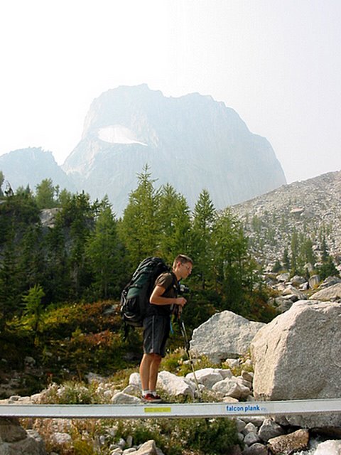
A handy dandy bridge crossing a glacier-fed stream. Snowpatch Spire, the last climbed of the Bugaboos (1940) is in the background. Posted by Picasa

Bugaboos hike-in


A handy bridge with Snowpatch Spire in the background. Snowpatch was the last of the spires to be climbed in 1940. Posted by Picasa

Hiking into the Bugaboos


Wow. This is impressive. After setting up a barricade of chicken wire around the truck to protect it from porcupines, who seem to find rubber tubing quite delightful., we set off on a hike to the Boulder Camp below the Conrad Kain Hut. Given that it was K's stag and all, we dropped an additional weight in his pack - 32 cans of beer. At 355mL, that's roughly an additional 25 pounds - on top of the usual camping accoutrements of tent, sleeping bag, stove, gas, clothes, water and food.
The hike to the Conrad Kain hut is very short - roughly 3 miles up - but seriously steep (map here). There's 2200 feet of elevation gain to the hut, all of it attained in the last two miles. In places, the trail uses bolted cables, and in one spot, it utilizes a vertical metal ladder. However, the trail is in great shape and views are inspiring.
The prominent rock in the midst of the glacier is the Marmolata, about which more here. Suffice it to say that it's the smallest peak there. Posted by Picasa